Ratanakiri Guide - All you need to know
A scarcely populated province, Ratanakiri shows considerable promise as an eco-tourism destination with plentiful waterfalls, volcanic lakes, a large national park and a number of waterways, all of which can be explored from the provincial capital of Banlung.
Located in the remote northeast of Cambodia, Ratanakiri has become one of the top eco-friendly tourist destinations in the country. Framed by the Mekong River to the west, Vietnam to the east, Laos to the north and Mondulkiri to the south, Ratanakiri province extends from the mountains of the Annamite Range in the north, across a hilly plateau between the Tonle San and Tonle Srepok rivers, to tropical deciduous forests in the south.

Ecotourism in Ratanakiri
In this scarcely populated province, you’ll find neither temples nor vestiges of ancient civilizations, but a unique natural beauty and wealth of natural resources. Ratanakiri shows considerable promise as an eco-tourism destination with plentiful waterfalls, volcanic lakes, a large national park, a glimpse of the lifestyles of ethnic minoritie and a number of waterways, all of which can be explored from the provincial capital of Banlung.
History of Ratanakiri
For over a millennium, Ratanakiri has been occupied by the Khmer Loeu (Highland Khmer) people. During the region's early history, its Khmer Loeu inhabitants were exploited as slaves by neighbouring empires. The slave trade economy ended during the French colonial era, but a harsh Khmerization campaign after Cambodia's independence again threatened Khmer Loeu ways of life. The Khmer Rouge built its headquarters in the province in the 1960s, and bombing during the Vietnam War devastated the region.
Today, rapid development in the province is altering traditional ways of life. The Jarai, Tompuon, Brau and Kreung are the Khmer Leu, with their own languages, traditions and customs. There is also a large Lao population throughout the province and multiple languages will be heard in villages such as Veun Sai.
Culture
There’re 8 different hill tribes ethnic minorities, including Tumpoun, Kreung and Charay are the most dominated groups. The minor groups like to live in the jungles, hills, mountains in small separated villages where they make their living by traditional ways of farming, hunting and collecting fruits.
The locals here mostly follow Buddhism and Animism. They believe in spirits, derived from their animism beliefs.
Due to a variety of natural resources, Ratanakiri is known for the land of gold, mine, gemstone, granite, onyx, fertile red soil, water sources and qualified wood. In addition to agriculture, today Ratanakiri has been developing its major industry of tourism.
Main attractions in Ratanakiri
- Yeak Loam Lake: About 5km southeast of Banlung, Yeak Loam Lake is the most beautiful lake formed by a volcanic eruption almost 4,000 years ago in Ratanakiri. With 50m deep, 800m diameter and a walking path around the lake of 2,500m, Yeak Loam Lake is suitable for swimming, hiking and enjoying a panorama of the surrounding flora and fauna. This is also a place of worship for hill tribes and handicrafts made by hill tribes living nearby for sale.
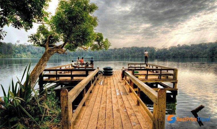
Yeak Loam Lake
- Eisey Patamak Mountain: About 2km west of Banlung provincial town, Eisey Patamak Mountain (Phnom Svay) is an awesome and peaceful place to behold the spellbinding serenity of the surrounding countryside. At the foot of the mountain is Wat Isana Rattanaram, where villagers living in Ban Loung come to worship. At the top, a large statue of the reclining Buddha reaching nirvana was built in 1994. Eisey Patamak Mountain is the favorite haunt for adventure lovers, especially trekkers who can feast the eye to picturesque view as well as pleasant climate.
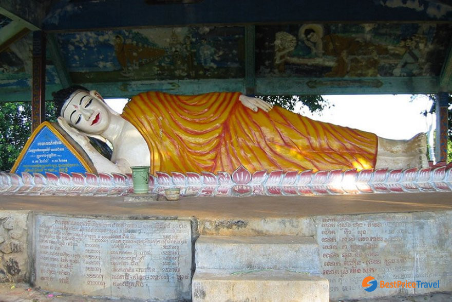
Reclining Buddha at Eisey Patamak Mountain
- A series of waterfalls: The neareast one is Kachang Waterfall, located 6km northwest of Banlung in the Kontung stream. Below the Kachang Waterfall, visitors can visit Katieng Waterfall located in the same Kontung stream. To the south of Banlung, there’re two striking waterfalls, four-terraced Ou'Sean Lair Waterfall and 18-meter-high Ou'Sensranoh Waterfall, with the water flowing throughout the year. Visit these beautiful waterfalls, you can get an escape into the magnificent landscape, take a bath, listen to the birds’ songs and enjoy the fresh air with fresh mist surround the waterfall.
- Virachey National Park: Situated 45 km north of Banlung, Virachey National Park has a total land area of 332,500 ha. There’s a great diversity of plants and trees in the forest, as well as different kinds of animals and birds.

Virachey National Park jungle trek
- Norng Kabat Forest: Aside from the great biodiversity of animals and birds in the forest, visitors can visit the ethnic villages to get a deep insight of ethnic culture (tradition belief, festival, dancing, music, etc.).
- Lumphat Wildlife Sanctuary: Lumphat Wildlife Sanctuary is situated 37km to south of Banlung. You can find multitude special kinds of animals and birds like tigers, elephants, red-headed vultures in the land 250,000 ha.
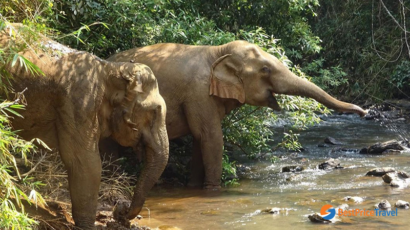
Lumphat Wildlife Sanctuary
Climate
Like the rest of Cambodia, Ratanakiri Province has a typically tropical climate with 3 main seasons: rainy season from June to October, cool season from November to February and hot season from March to May. Averagely, the temperature ranges between 20 and 32oC. You should avoid the rainy season to better plan a trip to Ratanakiri.
Known for its red dirt, Ratanakiri becomes a dust-bowl in the dry season and a mud pit in the wet season. While the roads have improved considerably, in the height of wet season some are virtually impassable. A good time to visit is in November, when the rains have stopped and the dust has not got too far out of hand.
Transportation
Tourists can get there by overnight car or by boat (in rainy season) from Phnom Penh – Kampong Cham – Kracheh, due to the long distance of 636km. In Ratanakiri, the popular kinds of transportation to get around include car, motorbike, boat and trekking.
Most travelers who make the effort to reach here tend to stay at least three nights, exploring the waterfalls, minority villages and cemeteries and perhaps doing an overnight (or longer) trip into the national park. Tourism is still a developing business here and that things may not always turn out quite as you expect.