Vietnam climate and average temperature
Although the territory of Vietnam is entirely located in the tropics, the climate of Vietnam has distributed into 3 separate climatic regions according to the Köppen climate classification with the North and North Central regions being the humid subtropical climate. The North consists of 4 seasons: Spring, Fall, and Winter. The Central and South Central regions are a tropical monsoon climate, the southernmost part of Central Vietnam and the South has tropical savanna characteristics. At the same time, because it is located on the southeastern edge of continental Asia, bordering the South China Sea (part of the Pacific Ocean), it is directly influenced by the type of trade monsoon climate, often blowing in low latitude regions. The South usually has 2 seasons: rainy season and dry season. It is necessary to distinguish the temperate and tropical climate, the temperate climate has 4 seasons, Spring, Summer, Autumn, and Winter and the tropical climate is only two seasons, sunny and rainy. In Vietnam, the northern part has 4 seasons so it is completely in the temperate zone, the south part 2 seasons should be completely in the tropics.
Before traveling somewhere, you should find out about its climate. Here is what you need to know about Vietnam climate
1. Regional climate characteristics
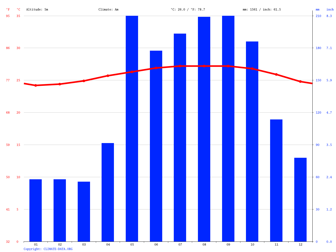
Due to geographical location, our country has received a large amount of solar heat, so Vietnam temperature is high all year round, averaging over 21 ° c and increasing gradually from the North to the South of heavy rainfall (1500 - 2000 mm / year). and air humidity above 80%. So our climate compared to other countries in the same latitude our country has a colder winter and a cooler summer. On average, 1m2 receives over 1 million kilos of thermal calories. The number of sunshine hours is from 1400-3000 hours/year.
Northern climate region
Includes the northern part of the Hoang Lien Son range. This region has a humid subtropical climate, but its tropical properties are reduced with the four distinct seasons: spring, summer, autumn, and winter. However, this climate region is characterized by instability with start and end times of seasons and temperature.
- Northeast region
including the Northern Plains, Northern Mountains, and Midlands (the eastern part of Hoang Lien Son Range). This region has relatively flat terrain (the Northern Delta) and is low. In the north, there are mountain ranges not very high (1000 m ÷ <3000 m), lying in the fan shape on the northeast-southwest, north-south, then north - northwest-southeast directions, clustered towards the direction Tam Dao mountain range (which is the bow of Dong Trieu, Bac Son, Ngan Son, Song Gam, and ending with Hoang Lien Son mountain range on the border with the Northwest region), which does not prevent but forms wind-leading slopes. Northeast and Northern winds usually appear in winter. This area is contiguous to the Gulf of Tonkin to the East, the West is blocked by the highest Hoang Lien Son range in Vietnam (> 3001 m), so it is influenced by ocean climate more than the Northwestern region. Therefore, the Northeast is directly affected by tropical storms, in the summer, less influenced by foehn winds.
- Northwestern region
Although the general climate is not much different between regions, its appearance is not the same horizontally and vertically. The Hoang Lien Son mountain range runs one block in a northwest-southeast direction, playing the role of a bulwark to prevent winter winds (northeast-southwest) from passing into Northwestern territory without greatly weakened, as opposed to the Northeast, a system of arcs extending in a fan-like shape makes it possible for cold waves to reach as far as the Red River Delta and further south. Therefore, unless under the influence of elevation, the Northwestern climate is generally warmer than the Northeast, the difference can be 2-3 ° C. In the mountains, the slope direction of the slopes plays an important role in the heat - humidity regime, the windward (east) side receives heavy rainfall while the west side facilitates foehn winds formed when blowing down valleys, most notably in the Northwest.
In general, in terms of midland and mountainous areas, climate study is very important because the deformation of the climate occurs in each small area. Climate events in the mountains are extremeness, especially in the context of reduced forest cover, and degradation of the soils. Heavy and concentrated rain caused floods. When combined with a number of conditions, flash floods occur. droughts often occur in the dry season but sometimes droughts are beyond the tolerance of plants.
Truong Son climate region
The Eastern Truong Son climatic region includes the Central region in the eastern part of the Truong Son mountain range, from Hoanh Son to Mui Dinh where the rainy season deviates completely from autumn and winter.
It consists of the eastern part of the Truong Son range, extending from the south of the Hoanh Son range to Phan Thiet. This is the transitional climate zone between the two climates mentioned above and features the tropical monsoon climate. This domain can be further divided into two regions:
- Northcentral region
This is the northern region of Hai Van mountain pass, sometimes with cold weather and hot dry periods caused by southwest wind. In the winter, due to the formation of this region running along the East Coast in the Northwest - Southeast direction, directly facing the prevailing monsoon direction blowing in this season is the Northeast monsoon. The Truong Son mountain range is relatively high in the west (Phong Nha - Ke Bang mountain range) and in the south (at Hai Van mountain pass in the Bach Ma mountain range) at the end of the northeast monsoon. So this area is still affected by the cold weather brought by the northeast monsoon and often accompanied by heavy rain (especially in Thua Thien - Hue) due to the monsoon blowing in the northeast direction with the steam from the sea, slightly different from the dry weather of the North in the winter. The northeast monsoon blowing here is often weakened and blocked by the Bach Ma mountain range which has little effect on the southern regions. In the summer, when the strong southwest monsoon blows from the Gulf of Thailand through the vast continent to the Truong Son mountain range, all the rain is poured down the western flanks of Truong Son but continues to cross the mountains to blow to this region. At this time, due to the absence of steam, the Southwest monsoon causes hot and dry weather (sometimes up to> 40 ° C, the humidity is only about 50 % - 60%), this wind is called foehn wind.
- Middle South coastal
This is a coastal plain in the South Central Coast. It is in the south of Hai Van Pass similar to the north of Hai Van Pass, however, the temperature is higher and sometimes there are winter winters that are not long, the effect westerly winds are not as great as in the North Central Coast.
An important feature of this climate region is that the rainy and dry seasons are not at the same time as the other two seasons. In Summer, while the country has the largest rainfall, this region is in the driest period.
Southern climates region
The southern climatic region includes the South and the Central Highlands. These areas have sub-equatorial climates, high year-round temperatures, with a deep rainy and dry season.
In the high mountains of our country, the climate varies with altitude and slope direction.
It includes territories of the Central Highlands and the South. This region has a tropical savanna climate with two seasons: the dry season and the rainy season (from April to October 10-11). All year-round, the temperature of this region is high. The climate of this region is less volatile during the year.
- South Central Highlands (Central Highlands)
- Southern plain
Due to geographical location, our country has received a large amount of solar heat, so the temperature is high all year round
2. Natural disasters
On average, in a year, our country had 10 storms in the East Sea, over 30 northeast monsoon winds, heavy rainfall, floods, drought, hot winds, etc.
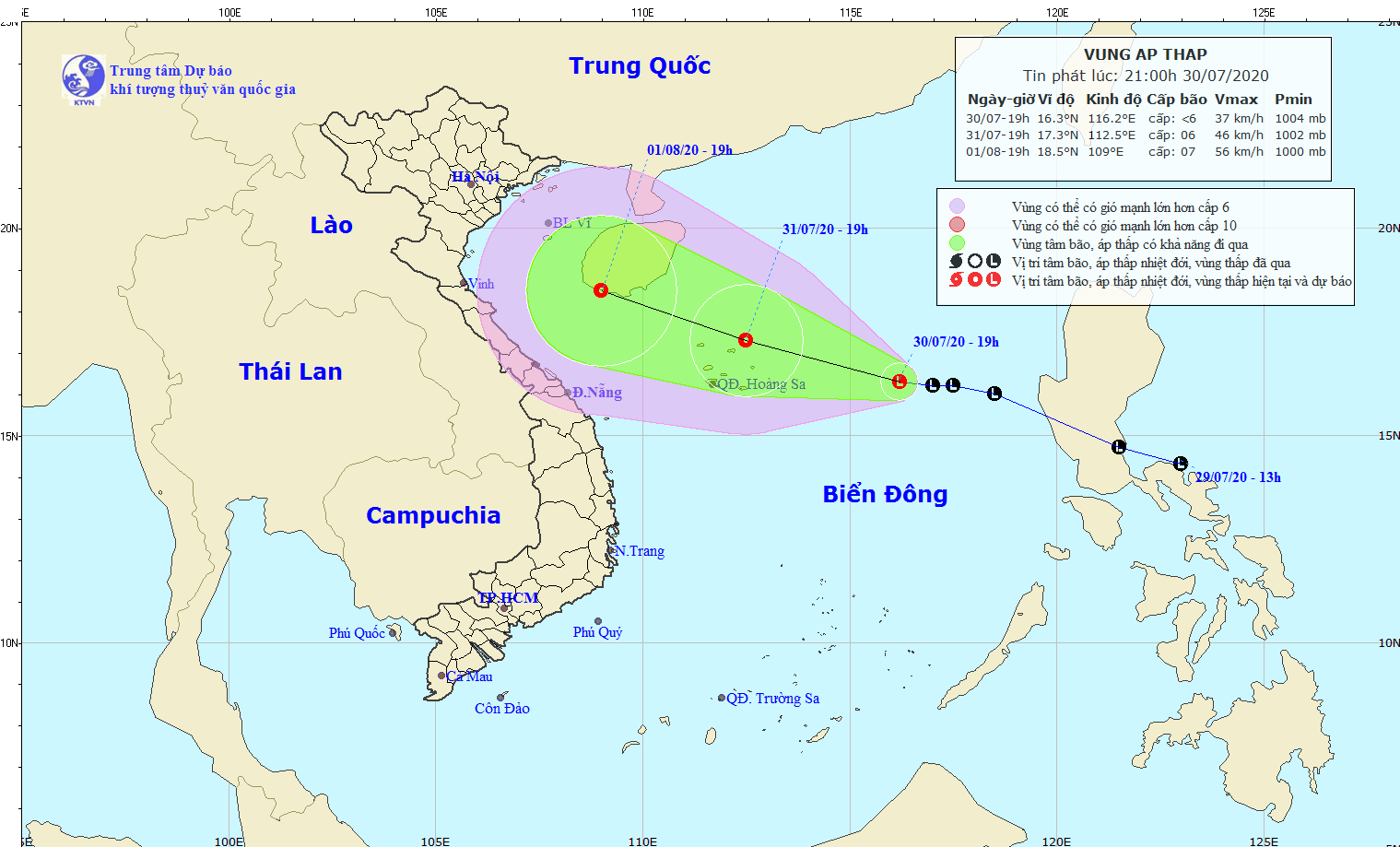
The storm is a special and dangerous weather phenomenon because it is a very strong form of turbulence of the atmospheric circulation causing heavy rain, strong winds with great devastation in a large area.
Storms in Vietnam are most likely to arise from the East sea (40% of all storms) and the western Pacific Ocean (60% of total storms)
Tropical storms are formed on hot waters, have high humidity and very unstable atmosphere, so they often occur in the summer and have become the season rule. The typhoon season in Vietnam usually lasts from May to December and occurs early in the Northern region, slowing down to the South. On average, there are 3-4 storms in Vietnam every year.
On average, in a year, our country had 10 storms in the East Sea, over 30 northeast monsoon winds, heavy rainfall, floods, hot wind
In the North, from Quang Ninh to Thanh Hoa, the typhoon season starts early, from May, and ends soon, in October. On average, there are about 1.4 typhoons every year in this area. Most frequently occurs in August and September. In the Central and South Central regions, the typhoon season ends later, in November and December. Here, September, October, and November often have more storms than other months. On average, there are more than 2 typhoons in this area each year. There are very few storms in the South, usually, it takes more than 10 years for a typhoon.
Hang Moon
Image sources: Internet


Questions & Answers
 Vietnam Weather October: Temperature & Top Places to VisitJuly 11, 2025 - 7084 Views
 Vietnam Weather in March: Temperatures & Best Places to VisitAugust 22, 2024 - 2907 Views
 Vietnam Weather in April: Temperatures & Best Places to VisitAugust 22, 2024 - 2045 Views